
Vienna U-Bahn network map
The 5 lines (U1, U2, U3, U4, U6) and 99 stations of the Vienna metro at a glance, with every interchange marked. Download it as a PNG or as a printable PDF.
The Vienna metro map explained
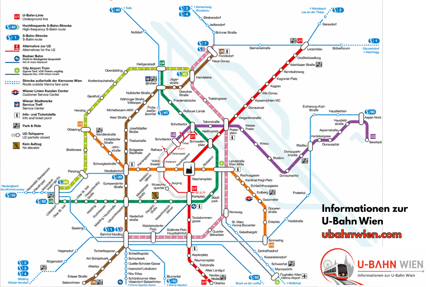
99 stations, 110 stops (interchanges counted once per line), about 83 km of track and 10 interchange stations.
Vienna U-Bahn map PDF — download
The Vienna U-Bahn map as a PDF stays sharp when you zoom in or print it, and it works offline — handy down in the stations, where mobile coverage is patchy. You get all 5 lines, the 99 stations and the 10 interchanges in your pocket.
Legend: the 5 lines and their colours
The Vienna U-Bahn has five lines: U1 (red), U2 (purple), U3 (orange), U4 (green) and U6 (brown). You will not find a U5 on the map — it is not in service yet.
The 10 interchange stations on the network
At 10 interchange stations you can change line without buying or validating anything new: transfers are always included in the Vienna fare. The busiest of them is Karlsplatz (U1, U2, U4) — the only station where three metro lines meet.
Why there is no U5 on the map
The U5 is not in service yet. Civil works on the first stage (Karlsplatz – Frankhplatz) are being completed, but in November 2025 the opening was pushed back to 2030: the U5 will only start once the U2 is diverted at Rathaus towards Matzleinsdorfer Platz. It will be Vienna’s first fully automatic, driverless line.
In short: if you ride the metro in Vienna today, you have five lines to choose from — U1, U2, U3, U4 and U6. Looking for a U5 on the map is a waste of time, and the gap in the numbering is not a printing error but the current state of play. The same goes for the missing U7 and U8: they do not exist either. A U5 already appeared in early network plans but was not built at the time, which is why the numbering still jumps from U4 to U6.
Vienna U-Bahn map: frequently asked questions
Right here on this page: click «Map as PDF» and the file is saved to your device. The map is also available as a PNG. Both versions are free, print well and work without an internet connection.
5 lines (U1, U2, U3, U4 and U6) and 99 stations. If you count the interchange stations once per line, you get 110 stops. The network is about 83 km long.
Because it is not in service yet. The first stage (Karlsplatz – Frankhplatz) is being built, but in November 2025 the opening was pushed back to 2030. The U5 will be Vienna’s first fully automatic, driverless line.
Yes. Since 6 December 2024 the U2 has been running all the way from Seestadt to Karlsplatz again. Older network maps and many guidebooks still show the earlier closure between Schottentor and Karlsplatz — that gap is gone.
Karlsplatz, where the U1, U2 and U4 meet. The other nine interchange stations each connect two lines.
No. With a valid Wiener Linien ticket you can change as often as you like — between metro, tram, bus and S-Bahn inside the Vienna core zone. A single ticket costs €3.20 and is valid for the whole journey in one direction.